
Thank you for supporting this site ❤️
Make a donation
Make a donation
Oro Valley topographic map
Click on the map to display elevation.
Thank you for supporting this site ❤️
Make a donation
Make a donation
About this map
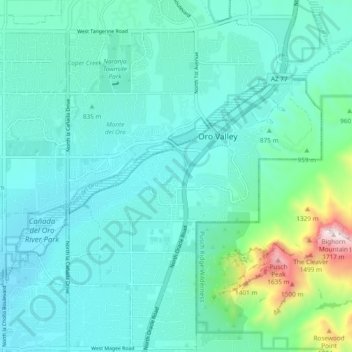
Name: Oro Valley topographic map, elevation, terrain.
Location: Oro Valley, Pima County, Arizona, 85737, United States (32.35091 -111.00649 32.43091 -110.92649)
Average elevation: 874 m
Minimum elevation: 714 m
Maximum elevation: 1,721 m
Thank you for supporting this site ❤️
Make a donation
Make a donation
Other topographic maps
Click on a map to view its topography, its elevation and its terrain.