
Thank you for supporting this site ❤️
Make a donation
Make a donation
Prince Islands topographic map
Click on the map to display elevation.
Thank you for supporting this site ❤️
Make a donation
Make a donation
Prince Islands
All islands contain hills, the highest being Büyükada's Aya Yorgi Hill with 203 meters of elevation.
Thank you for supporting this site ❤️
Make a donation
Make a donation
About this map
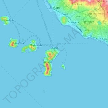
Name: Prince Islands topographic map, elevation, terrain.
Location: Prince Islands, Istanbul, Marmara Region, Turkey (40.81803 28.96917 40.91449 29.14822)
Average elevation: 12 m
Minimum elevation: -3 m
Maximum elevation: 218 m
Thank you for supporting this site ❤️
Make a donation
Make a donation
Other topographic maps
Click on a map to view its topography, its elevation and its terrain.
Thank you for supporting this site ❤️
Make a donation
Make a donation
Thank you for supporting this site ❤️
Make a donation
Make a donation