
Thank you for supporting this site ❤️
Make a donation
Make a donation
Waitākere Bay topographic map
Click on the map to display elevation.
Thank you for supporting this site ❤️
Make a donation
Make a donation
About this map
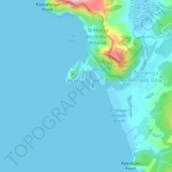
Name: Waitākere Bay topographic map, elevation, terrain.
Average elevation: 18 m
Minimum elevation: 0 m
Maximum elevation: 183 m
Thank you for supporting this site ❤️
Make a donation
Make a donation
Other topographic maps
Click on a map to view its topography, its elevation and its terrain.
Bethells Beach
New Zealand > Auckland > Waitakere Ranges > Te Henga / Bethells Beach
Average elevation: 33 m