

Atlanta topographic map
Click on the map to display elevation.
Atlanta
Atlanta occupies a high, rolling part of the Georgia Piedmont, a physiographic region described as a landscape of low hills and narrow valleys between the Blue Ridge Mountains and the Upper Coastal Plain. Around downtown and Fulton County, the terrain is gently dissected rather than flat, with broad urban ridges, shallow creek valleys, and a generally elevated plateau-like character; the city is commonly described as lying just over 1,000 feet (about 300 meters) above sea level, while lower ground appears along drainage corridors such as Peachtree Creek, Proctor Creek, Utoy Creek, and the Chattahoochee River system. The local relief is moderate but persistent, producing a landscape of undulating neighborhoods, wooded slopes, and stream-cut troughs rather than dramatic mountains, while isolated higher features such as Stone Mountain to the east emphasize the Piedmont’s pattern of rounded uplands and occasional resistant rock masses. The overall physical character is therefore that of an elevated, humid, forested urban Piedmont terrain: a city built across ridgelines and rolling hills, with elevation gradually stepping down toward its creeks and river valleys.
About this map
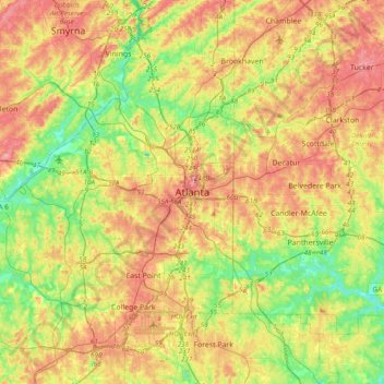
Name: Atlanta topographic map, elevation, terrain.
Location: Atlanta, Fulton County, Georgia, 30303, United States (33.58899 -84.55026 33.90899 -84.23026)
Average elevation: 285 m
Minimum elevation: 221 m
Maximum elevation: 359 m
Other topographic maps
Click on a map to view its topography, its elevation and its terrain.
Atlanta
United States > Georgia > Fulton County
Atlanta features a varied topography characterized by its rolling hills and elevated terrain. The city sits at an average elevation of approximately 1,050 feet (320 meters) above sea level, with elevations ranging from about 725 feet (221 meters) to 1,175 feet (358 meters) in the surrounding areas. This…
Average elevation: 284 m
Milton
United States > Georgia > Fulton County
According to the U.S. Census Bureau, the city of Milton has a total area of 39.2 square miles (101.4 km2), of which 38.5 square miles (99.8 km2) is land and 0.62 square miles (1.6 km2), or 1.59%, is water. The elevation ranges from 950 to 1,280 feet (290 to 390 m) above sea level.
Average elevation: 330 m

Johns Creek
United States > Georgia > Fulton County
Johns Creek is located in northeastern Fulton County and is centered at 34°1′44″N 84°11′55″W / 34.02889°N 84.19861°W / 34.02889; -84.19861 (34.0289259, -84.1985790). The elevation ranges from 880 feet (270 m) above sea level along the Chattahoochee River to 1,180 feet (360 m) in the Ocee…
Average elevation: 314 m



Atlanta
United States > Georgia > Fulton County
Atlanta (/ætˈlæntə/ at-LAN-tə, or /ætˈlænə/ at-LAN-ə) is the capital and most populous city of the U.S. state of Georgia. It is the seat of Fulton County, although a portion of the city extends into neighboring DeKalb County. With a population of 498,715 living within the city limits, Atlanta is the…
Average elevation: 284 m
Atlanta
United States > Georgia > Fulton County
Atlanta (/ætˈlæntə/ at-LAN-tə) is the capital and most populous city of the U.S. state of Georgia. It is the seat of Fulton County, the most populous county in Georgia, although a portion of the city extends into neighboring DeKalb county. With a population of 498,715 living within the city limits, it is…
Average elevation: 284 m
Atlanta
United States > Georgia > Fulton County
Atlanta is the capital and most populous city of the U.S. state of Georgia. It is the county seat of Fulton County and extends into neighboring DeKalb County. With a population of 498,715 at the 2020 census and an estimated 520,070 in 2024, Atlanta is the eighth-most populous city in the Southeast and the…
Average elevation: 284 m
Atlanta
United States > Georgia > Fulton County
Atlanta (/ætˈlæn(t)ə/ at-LAN-(t)ə) is the capital and most populous city in the U.S. state of Georgia. It is the seat of Fulton County, and a portion of the city extends into neighboring DeKalb County. While not included in city limits, unincorporated areas that carry an Atlanta address spill into…
Average elevation: 284 m
Atlanta
United States > Georgia > Fulton County
Atlanta (/ætˈlæntə/ at-LAN-tə) is the capital and most populous city in the U.S. state of Georgia. It is the seat of Fulton County, and a portion of the city extends into neighboring DeKalb County. With a population of 510,823 (2023 estimate) living within the city limits, Atlanta is the eighth most…
Average elevation: 284 m
Johns Creek
United States > Georgia > Fulton County
Johns Creek is located in northeastern Fulton County. The elevation ranges from 880 feet (270 m) above sea level along the Chattahoochee River to 1,180 feet (360 m) in the Ocee area along the Alpharetta border. Johns Creek is bounded to the south by the Chattahoochee River and Gwinnett County, and on the…
Average elevation: 314 m
Milton
United States > Georgia > Fulton County
According to the U.S. Census Bureau, the city of Milton has a total area of 39.2 square miles (101.4 km2), of which 38.5 square miles (99.8 km2) is land and 0.62 square miles (1.6 km2), or 1.59%, is water. The elevation ranges from 950 to 1,280 feet (290 to 390 m) above sea level.
Average elevation: 330 m
Atlanta
United States > Georgia > Fulton County
Atlanta (/ætˈlæn(t)ə/ at-LAN-(t)ə) is the capital and most populous city in the U.S. state of Georgia. It is the seat of Fulton County, and a portion of the city extends into neighboring DeKalb County. With a population of 498,715 living within the city limits, Atlanta is the eighth most populous city in…
Average elevation: 284 m
Atlanta
United States > Georgia > Fulton County
Atlanta (/ætˈlæntə/ at-LAN-tə) is the capital and most populous city in the U.S. state of Georgia. It is the seat of Fulton County, and a portion of the city extends into neighboring DeKalb County. With a population of 510,823 living within the city limits, Atlanta is the eighth most populous city in the…
Average elevation: 284 m

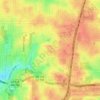
Milton
United States > Georgia > Fulton County
According to the U.S. Census Bureau, the city of Milton has a total area of 39.2 square miles (101.4 km2), of which 38.5 square miles (99.8 km2) is land and 0.62 square miles (1.6 km2), or 1.59%, is water. The elevation ranges from 950 to 1,280 feet (290 to 390 m) above sea level.
Average elevation: 330 m