
Mount Cabalian topographic map
Click on the map to display elevation.
Mount Cabalian
The stratovolcano has an elevation of 945 metres (3,100 ft) with a base diameter of 8.5 kilometres (5.3 mi). The predominant rock type is andesite. Beside solfataras, other thermal features present are hot springs located on the east and west flank of the volcano. Mainit Hot Spring in the municipality of Anahawan, Southern Leyte has a temperature of 63.4–63.9 °C (146.1–147.0 °F).
About this map
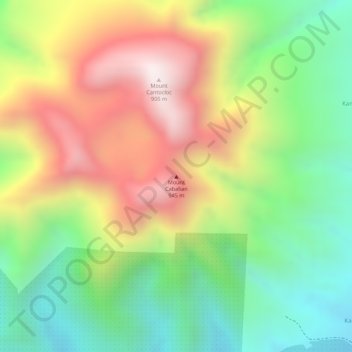
Name: Mount Cabalian topographic map, elevation, terrain.
Average elevation: 524 m
Minimum elevation: 189 m
Maximum elevation: 911 m
Other topographic maps
Click on a map to view its topography, its elevation and its terrain.
Limasawa
Limasawa was the second island (after Suluan) of the Philippines that the Magellan Expedition landed on. Antonio Pigafetta documented the island as "Mazaua". He described it as being inhabited with cultivated fields. In March 28, 1521 the Magellan Expedition met with two rulers, Rajah Colambu and Rahah Siaui,…
Average elevation: 1 m