
Kargil tehsil topographic map
Interactive map
Click on the map to display elevation.
About this map
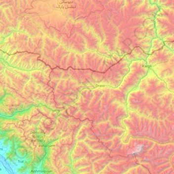
Name: Kargil tehsil topographic map, elevation, terrain.
Location: Kargil tehsil, Kargil district, Ladakh, 194103, Inde (34.09791 75.32697 34.74146 76.72019)
Average elevation: 4,005 m
Minimum elevation: 1,588 m
Maximum elevation: 7,057 m
Other topographic maps
Click on a map to view its topography, its elevation and its terrain.
Namche
Inde > Ladakh > Kargil tehsil
Namche, Kargil tehsil, Kargil District, Ladakh, Inde
Average elevation: 3,861 m
Tiger Hill, Kargil
Inde > Ladakh > Kargil tehsil
Tiger Hill, Kargil, Kargil tehsil, Kargil District, Ladakh, Inde
Average elevation: 4,537 m
Kargil
Inde > Ladakh > Kargil tehsil
Kargil, Kargil tehsil, Kargil district, Ladakh, 194103, Inde
Average elevation: 3,261 m