
Thank you for supporting this site ❤️
Make a donation
Make a donation
Grimwith Reservoir topographic map
Click on the map to display elevation.
Thank you for supporting this site ❤️
Make a donation
Make a donation
About this map
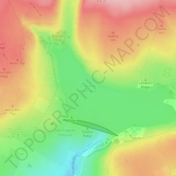
Name: Grimwith Reservoir topographic map, elevation, terrain.
Average elevation: 320 m
Minimum elevation: 229 m
Maximum elevation: 406 m
Thank you for supporting this site ❤️
Make a donation
Make a donation
Other topographic maps
Click on a map to view its topography, its elevation and its terrain.
Burton in Lonsdale
United Kingdom > England > North Yorkshire > Craven District
Average elevation: 101 m
River Aire
United Kingdom > England > North Yorkshire > Craven District > Malham > Hanlith
Average elevation: 237 m
Thank you for supporting this site ❤️
Make a donation
Make a donation
Bastow Wood
United Kingdom > England > North Yorkshire > Craven District > Conistone
Average elevation: 244 m