
Highclere Castle topographic map
Interactive map
Click on the map to display elevation.
About this map
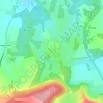
Name: Highclere Castle topographic map, elevation, terrain.
Average elevation: 166 m
Minimum elevation: 119 m
Maximum elevation: 278 m
Other topographic maps
Click on a map to view its topography, its elevation and its terrain.
West Heath
United Kingdom > England > Basingstoke and Deane > West Heath
West Heath, Basingstoke and Deane, Hampshire, South East, England, RG26 5LE, United Kingdom
Average elevation: 94 m
Heath Row
United Kingdom > England > Basingstoke and Deane > Ashe
Heath Row, Overton, Ashe, Basingstoke and Deane, Hampshire, South East England, England, United Kingdom
Average elevation: 112 m
Milford Lake
United Kingdom > England > Basingstoke and Deane
Milford Lake, Foxs Lane, Highclere, Basingstoke and Deane, Hampshire, South East, England, RG20 9EH, United Kingdom
Average elevation: 134 m
Sherborne St. John
United Kingdom > England > Basingstoke and Deane
Sherborne St. John, Basingstoke and Deane, Hampshire, South East, England, United Kingdom
Average elevation: 79 m