
Orreaga/Roncesvalles topographic map
Interactive map
Click on the map to display elevation.
About this map
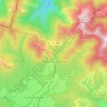
Name: Orreaga/Roncesvalles topographic map, elevation, terrain.
Average elevation: 1,025 m
Minimum elevation: 583 m
Maximum elevation: 1,533 m
Roncesvalles (/ˈrɒnsəvæl(z)/ RON-sə-val(z), Spanish: [ronθezˈβaʎes]; Basque: Orreaga [oreaɣa]; Aragonese: Ronzesbals [ronθezˈbals]; French: Roncevaux [ʁɔ̃s(ə)vo]) is a small village and municipality in Navarre, northern Spain. It is situated on the small river Urrobi at an altitude of some 900 metres (3,000 ft) in the Pyrenees, about 4 kilometres (2.5 mi) from the French border as the crow flies, or 21 kilometres (13 mi) by road.