
Make a donation
Heishui County topographic map
Click on the map to display elevation.
Make a donation
Heishui County
Heishui County (Chinese: 黑水县; Tibetan: ཁྲོ་ཆུ་རྫོང་།; Qiang: Vvlukvua) is a county in the north of Sichuan Province, China. It is under the administration of the Ngawa Tibetan and Qiang Autonomous Prefecture. The county has an area of 1,682 square miles (4,356 km2) and its average elevation is 11,627 feet (3,544 m). As of 2016, the county has a population of 61,744.
Make a donation
About this map
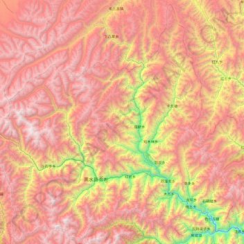
Name: Heishui County topographic map, elevation, terrain.
Average elevation: 3,656 m
Minimum elevation: 1,810 m
Maximum elevation: 5,139 m
Make a donation
Other topographic maps
Click on a map to view its topography, its elevation and its terrain.
Jiuzhaigou
China > Sichuan > Jiuzhaigou County
The county consists of nine villages in a valley in Sichuan Province. The main ethnic group in the county is Han, with the second being Tibetan. The county seat has an altitude of about 1,400 m (4,600 ft).[1] It has a total area of 2,041 square miles (5,286 km2).[2] As of 2015, the county's total population…
Average elevation: 2,520 m
Qingcheng Mountain
"Located at the peak of Mount Qingcheng with an altitude over 1,500 m, Shangqing Palace marks the end of the touring route of Mount Qingcheng. Buildings such as Laojun Hall, Sanqing Hall, Wenwu Hall, and Tao Te Ching Preaching Hall in the Taoist temple of Shangqing Palace with several cultural relics, were…
Average elevation: 972 m
Make a donation
Mount Emei
China > Sichuan > Emeishan City > Emeishan
The flora of Mount Emei varies with elevation, from subtropical evergreen forests at lower elevations to subalpine shrubland around the summit. The mountain is notable for both its species richness and abundance of endemic plants.
Average elevation: 2,434 m
Make a donation
Make a donation
Make a donation
Tagong
A gompa is where the Tagong Monastery is located. The gompa is one of the most important in the in Tibetan Pel Lhagong. The Tagong Monastery was established with reference to a nearby sacred mountain, Mt. Yala or Zhara Lhaste, which is 5,820 metres (19,090 ft) in elevation.
Average elevation: 3,874 m
Make a donation
Make a donation
Make a donation
Make a donation
Make a donation
Make a donation
Make a donation
Make a donation
Make a donation
Make a donation
Large High Altitude Air Shower Observatory
China > Sichuan > Daocheng County
The Large High Altitude Air Shower Observatory (LHAASO) is a gamma-ray and cosmic-ray observatory in Daocheng, in the Garzê Tibetan Autonomous Prefecture in Sichuan, China. It is designed to observe air showers triggered by gamma rays and cosmic rays. The observatory is at an altitude of 4,410 metres (14,470…
Average elevation: 4,421 m
Make a donation
Make a donation
Make a donation
Make a donation
Make a donation
Make a donation
Make a donation
Make a donation
Make a donation
Make a donation
Make a donation