
Glencoe topographic map
Interactive map
Click on the map to display elevation.
About this map
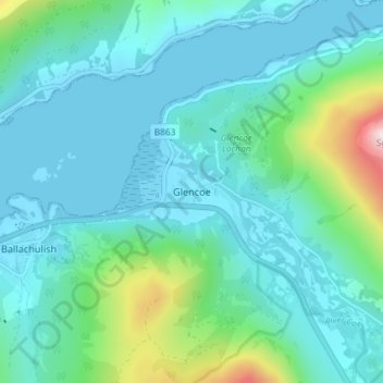
Name: Glencoe topographic map, elevation, terrain.
Location: Glencoe, Highland, Escocia, PH49 4HS, Reino Unido (56.66276 -5.12146 56.70276 -5.08146)
Average elevation: 114 m
Minimum elevation: -1 m
Maximum elevation: 682 m
Other topographic maps
Click on a map to view its topography, its elevation and its terrain.
Fort Augustus
Reino Unido > Escocia > Highland
Fort Augustus, Highland, Escocia, PH32 4AY, Reino Unido
Average elevation: 115 m
Laga
Reino Unido > Escocia > Highland
Laga, Highland, Escocia, PH36 4JW, Reino Unido
Average elevation: 135 m