
Thank you for supporting this site ❤️
Make a donation
Make a donation
Durmitor topographic map
Click on the map to display elevation.
Thank you for supporting this site ❤️
Make a donation
Make a donation
About this map
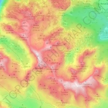
Name: Durmitor topographic map, elevation, terrain.
Location: Durmitor, Žabljak Municipality, Montenegro (43.11351 18.99818 43.15229 19.08860)
Average elevation: 1,950 m
Minimum elevation: 1,287 m
Maximum elevation: 2,463 m
Thank you for supporting this site ❤️
Make a donation
Make a donation
Other topographic maps
Click on a map to view its topography, its elevation and its terrain.