
Thank you for supporting this site ❤️
Make a donation
Make a donation
Bishop's Tachbrook topographic map
Click on the map to display elevation.
Thank you for supporting this site ❤️
Make a donation
Make a donation
About this map
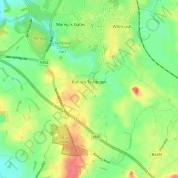
Name: Bishop's Tachbrook topographic map, elevation, terrain.
Average elevation: 70 m
Minimum elevation: 45 m
Maximum elevation: 104 m
Thank you for supporting this site ❤️
Make a donation
Make a donation
Other topographic maps
Click on a map to view its topography, its elevation and its terrain.
Rowington Green
United Kingdom > England > Warwickshire > Warwick > Rowington
Average elevation: 114 m
Hampton on the Hill
United Kingdom > England > Warwickshire > Warwick > Hampton on the Hill
Average elevation: 75 m
Thank you for supporting this site ❤️
Make a donation
Make a donation