
Thank you for supporting this site ❤️
Make a donation
Make a donation
Grouse Creek topographic map
Click on the map to display elevation.
Thank you for supporting this site ❤️
Make a donation
Make a donation
About this map
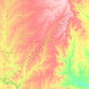
Name: Grouse Creek topographic map, elevation, terrain.
Location: Grouse Creek, Cowley County, Kansas, United States (37.00108 -96.92366 37.58659 -96.51583)
Average elevation: 381 m
Minimum elevation: 244 m
Maximum elevation: 503 m
Thank you for supporting this site ❤️
Make a donation
Make a donation
Other topographic maps
Click on a map to view its topography, its elevation and its terrain.
Arkansas City
United States > Kansas > Cowley County > Arkansas City > Arkansas City
Average elevation: 339 m