
Thank you for supporting this site ❤️
Make a donation
Make a donation
Farlington topographic map
Click on the map to display elevation.
Thank you for supporting this site ❤️
Make a donation
Make a donation
About this map
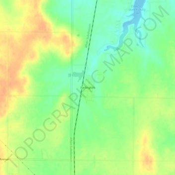
Name: Farlington topographic map, elevation, terrain.
Location: Farlington, Crawford County, Kansas, 66734, United States (37.59782 -94.84774 37.63782 -94.80774)
Average elevation: 308 m
Minimum elevation: 290 m
Maximum elevation: 325 m
Thank you for supporting this site ❤️
Make a donation
Make a donation
Other topographic maps
Click on a map to view its topography, its elevation and its terrain.
Thank you for supporting this site ❤️
Make a donation
Make a donation
Thank you for supporting this site ❤️
Make a donation
Make a donation