
Thank you for supporting this site ❤️
Make a donation
Make a donation
Oakwood topographic map
Click on the map to display elevation.
Thank you for supporting this site ❤️
Make a donation
Make a donation
About this map
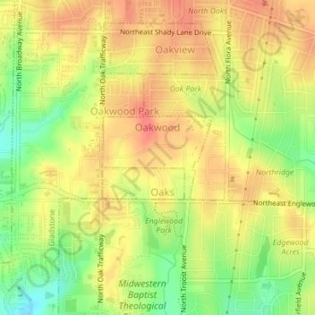
Name: Oakwood topographic map, elevation, terrain.
Location: Oakwood, Clay County, Missouri, United States (39.19570 -94.57639 39.20287 -94.56410)
Average elevation: 293 m
Minimum elevation: 260 m
Maximum elevation: 313 m
Thank you for supporting this site ❤️
Make a donation
Make a donation
Other topographic maps
Click on a map to view its topography, its elevation and its terrain.
Thank you for supporting this site ❤️
Make a donation
Make a donation
Kansas City, Clay County and St. Joseph Railroad
United States > Missouri > Clay County
Average elevation: 255 m
Thank you for supporting this site ❤️
Make a donation
Make a donation