
Thank you for supporting this site ❤️
Make a donation
Make a donation
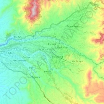
Perimetro Urbano Pereira topographic map
Click on the map to display elevation.
Thank you for supporting this site ❤️
Make a donation
Make a donation
Perimetro Urbano Pereira
Pereira is located on the central mountain range, on the Otún river valley, and part of the Cauca river valley. Pereira, like many Colombian cities, has high-elevation areas with difficult access or flat or steep parts. The streets are laid out according to the elevation of the respective zones.
Thank you for supporting this site ❤️
Make a donation
Make a donation
About this map
Name: Perimetro Urbano Pereira topographic map, elevation, terrain.
Average elevation: 1,486 m
Minimum elevation: 1,202 m
Maximum elevation: 2,104 m
Thank you for supporting this site ❤️
Make a donation
Make a donation
Other topographic maps
Click on a map to view its topography, its elevation and its terrain.