
Cherín topographic map
Interactive map
Click on the map to display elevation.
About this map
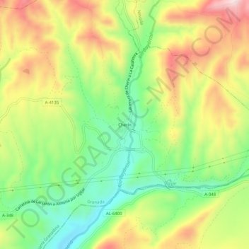
Name: Cherín topographic map, elevation, terrain.
Average elevation: 637 m
Minimum elevation: 456 m
Maximum elevation: 857 m
Other topographic maps
Click on a map to view its topography, its elevation and its terrain.
Jorairátar
España > Andalucía > Comarca de la Alpujarra Granadina > Ugíjar
Jorairátar, Ugíjar, Comarca de la Alpujarra Granadina, Granada, Andalucía, 18490, España
Average elevation: 794 m