
Schwein topographic map
Interactive map
Click on the map to display elevation.
About this map
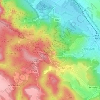
Name: Schwein topographic map, elevation, terrain.
Average elevation: 331 m
Minimum elevation: 253 m
Maximum elevation: 407 m
Other topographic maps
Click on a map to view its topography, its elevation and its terrain.
Nelke
Tschechien > Nordosten > Reichenberger Region > Groß Skal
Nelke, Groß Skal, Bezirk Semil, Reichenberger Region, Nordosten, 512 64, Tschechien
Average elevation: 324 m