
Thank you for supporting this site ❤️
Make a donation
Make a donation
Samrée topographic map
Click on the map to display elevation.
Thank you for supporting this site ❤️
Make a donation
Make a donation
About this map
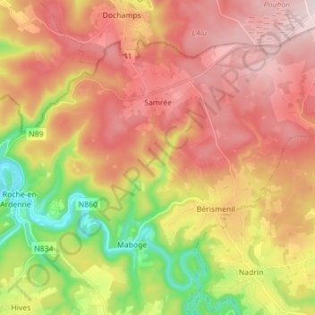
Name: Samrée topographic map, elevation, terrain.
Average elevation: 450 m
Minimum elevation: 211 m
Maximum elevation: 642 m
Thank you for supporting this site ❤️
Make a donation
Make a donation
Other topographic maps
Click on a map to view its topography, its elevation and its terrain.
Plain de Holset
Belgique > Luxembourg > Marche-en-Famenne > Durbuy > Grandhan
Average elevation: 182 m
Thank you for supporting this site ❤️
Make a donation
Make a donation