
Super Lioran topographic map
Click on the map to display elevation.
About this map
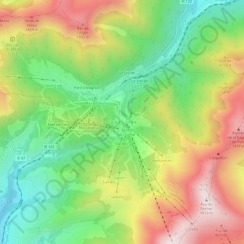
Name: Super Lioran topographic map, elevation, terrain.
Average elevation: 1,367 m
Minimum elevation: 1,022 m
Maximum elevation: 1,802 m
Other topographic maps
Click on a map to view its topography, its elevation and its terrain.
Aurillac
France > Auvergne-Rhône-Alpes > Cantal
Influenced by its altitude, Aurillac features an oceanic climate (Cfb), closely bordering on a warm-summer humid continental climate (Dfb) under the Köppen system. In spite of this, the city enjoys more than 2,100 hours of sunshine per year on average, but also a high amount of precipitations per year on…
Average elevation: 668 m
Lac de serre
France > Auvergne-Rhône-Alpes > Cantal > Saint-Saturnin > Le Fayet
Average elevation: 1,148 m
Mauriac
France > Auvergne-Rhône-Alpes > Cantal
Mauriac is in hilly terrain, with the main populated area falling into a zone at an altitude of about 350–450 metres, while the surrounding areas rise to about 760 metres in the volcanic foothills.
Average elevation: 671 m