Geolocate
👉 Easily get elevation data in JSON, GeoTIFF and KML formats using Elevation API
Thank you for supporting this site ❤️
Make a donation

Chirbury topographic map

Click on the map to display elevation.

👉 Easily get elevation data in JSON, GeoTIFF and KML formats using Elevation API
Thank you for supporting this site ❤️
Make a donation

About this map

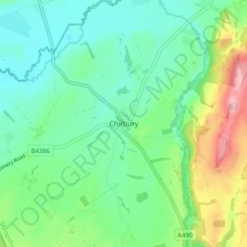
Name: Chirbury topographic map, elevation, terrain.

Location: Chirbury, Shropshire, England, SY15 6EP, United Kingdom (52.55886 -3.11100 52.59886 -3.07100)

Average elevation: 125 m

Minimum elevation: 74 m

Maximum elevation: 253 m

Other topographic maps

Click on a map to view its topography, its elevation and its terrain.

Broseley

United Kingdom > England > Shropshire

Average elevation: 142 m

Church Stretton

United Kingdom > England > Shropshire

Average elevation: 280 m

Aston Botterell

United Kingdom > England > Shropshire

Average elevation: 203 m

Much Wenlock

United Kingdom > England > Shropshire

Average elevation: 159 m

Cedars of Lebanon

United Kingdom > England > Shropshire > Atcham

Average elevation: 52 m

Romsley

United Kingdom > England > Shropshire

Average elevation: 134 m