
Little London Wood topographic map
Interactive map
Click on the map to display elevation.
About this map
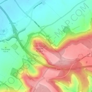
Name: Little London Wood topographic map, elevation, terrain.
Average elevation: 177 m
Minimum elevation: 112 m
Maximum elevation: 261 m
Other topographic maps
Click on a map to view its topography, its elevation and its terrain.
Long Wittenham
United Kingdom > England > South Oxfordshire > Long Wittenham
Long Wittenham, South Oxfordshire, Oxfordshire, South East England, England, OX14 4QH, United Kingdom
Average elevation: 55 m
Wallingford
United Kingdom > England > South Oxfordshire > Wallingford
Wallingford, Oxfordshire, South East, England, OX10 0AS, United Kingdom
Average elevation: 66 m