
Thank you for supporting this site ❤️
Make a donation
Make a donation
Lawrence Township topographic map
Click on the map to display elevation.
Thank you for supporting this site ❤️
Make a donation
Make a donation
About this map
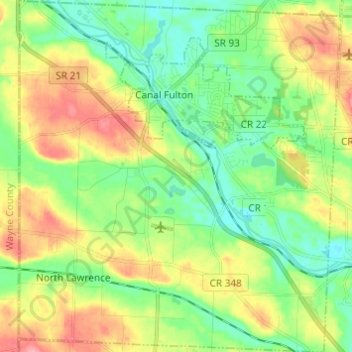
Name: Lawrence Township topographic map, elevation, terrain.
Location: Lawrence Township, Stark County, Ohio, 44666, United States (40.82229 -81.64802 40.91430 -81.53644)
Average elevation: 318 m
Minimum elevation: 281 m
Maximum elevation: 376 m
Thank you for supporting this site ❤️
Make a donation
Make a donation
Other topographic maps
Click on a map to view its topography, its elevation and its terrain.