
Thank you for supporting this site ❤️
Make a donation
Make a donation
Ellmau topographic map
Click on the map to display elevation.
Thank you for supporting this site ❤️
Make a donation
Make a donation
Ellmau
Ellmau is a municipality in the district of Kufstein in the Austrian region of Sölllandl. It lies 12 km southeast of Kufstein and 9 km west of Sankt Johann in Tirol. It is located at an elevation of 820 m above sea level. It was mentioned for the first time in the records in 1155 and is nowadays part of the Ski Welt skiing area.
Thank you for supporting this site ❤️
Make a donation
Make a donation
About this map
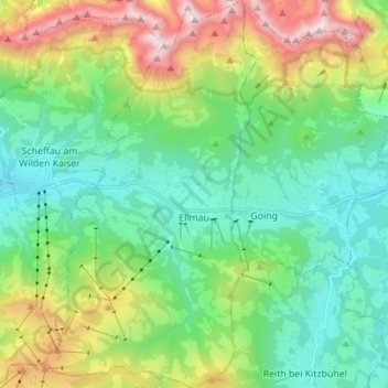
Name: Ellmau topographic map, elevation, terrain.
Location: Ellmau, Bezirk Kufstein, Tyrol, 6352, Austria (47.47244 12.24877 47.56612 12.32473)
Average elevation: 1,152 m
Minimum elevation: 636 m
Maximum elevation: 2,312 m
Thank you for supporting this site ❤️
Make a donation
Make a donation
Other topographic maps
Click on a map to view its topography, its elevation and its terrain.
Thank you for supporting this site ❤️
Make a donation
Make a donation
Thank you for supporting this site ❤️
Make a donation
Make a donation