
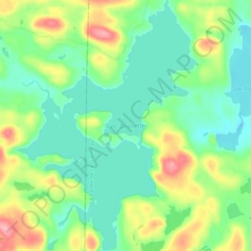
Lac Doolittle topographic map
Interactive map
Click on the map to display elevation.
About this map
Name: Lac Doolittle topographic map, elevation, terrain.
Average elevation: 379 m
Minimum elevation: 343 m
Maximum elevation: 453 m
Other topographic maps
Click on a map to view its topography, its elevation and its terrain.
Lac Rhéaume
Canada > Québec > La Vallée-de-la-Gatineau > Lac-Pythonga
Lac Rhéaume, Lac-Pythonga, La Vallée-de-la-Gatineau, Outaouais, Québec, Canada
Average elevation: 296 m
Lac Camatose
Canada > Québec > La Vallée-de-la-Gatineau > Lac-Pythonga
Lac Camatose, Lac-Pythonga, La Vallée-de-la-Gatineau, Outaouais, Québec, Canada
Average elevation: 365 m
Lac Jean Pere
Canada > Québec > La Vallée-de-la-Gatineau > Lac-Pythonga
Lac Jean Pere, Lac-Pythonga, La Vallée-de-la-Gatineau, Outaouais, Québec, Canada
Average elevation: 386 m
Ruisseau Antostagan
Canada > Québec > La Vallée-de-la-Gatineau > Lac-Pythonga
Ruisseau Antostagan, Lac-Pythonga, La Vallée-de-la-Gatineau, Outaouais, Québec, Canada
Average elevation: 395 m
Lac Camatose
Canada > Québec > La Vallée-de-la-Gatineau > Lac-Pythonga
Lac Camatose, Lac-Pythonga, La Vallée-de-la-Gatineau, Outaouais, Québec, Canada
Average elevation: 362 m