
Worcester topographic map
Interactive map
Click on the map to display elevation.
About this map
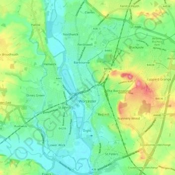
Name: Worcester topographic map, elevation, terrain.
Location: Worcester, Worcestershire, Inglaterra, Reino Unido (52.16164 -2.26321 52.23139 -2.15730)
Average elevation: 38 m
Minimum elevation: 10 m
Maximum elevation: 96 m
Other topographic maps
Click on a map to view its topography, its elevation and its terrain.
Malvern
Reino Unido > Inglaterra > Worcestershire > Malvern Hills
Malvern, Malvern Hills, Worcestershire, Inglaterra, WR14 2HX, Reino Unido
Average elevation: 95 m
Worcester
Reino Unido > Inglaterra > Worcestershire > Worcester
Worcester, Worcestershire, West Midlands, Inglaterra, WR1 2ZB, Reino Unido
Average elevation: 72 m