
Piddig topographic map
Click on the map to display elevation.
Piddig
Piddig's terrain is primarily hilly, with rice plains interspersed in between. It sits at an elevation higher than most towns in Ilocos Norte. The terrain is ideal for hiking given its variety of rivers, forests, and fields.
About this map
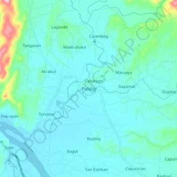
Name: Piddig topographic map, elevation, terrain.
Location: Piddig, Ilocos Norte, Ilocos Region, Philippines (18.12359 120.67653 18.20359 120.75653)
Average elevation: 55 m
Minimum elevation: 17 m
Maximum elevation: 301 m
Other topographic maps
Click on a map to view its topography, its elevation and its terrain.
Pagudpud
The town's topography includes mountains, hills, valleys and flat coastal land.
Average elevation: 71 m
La Paz Sand Dunes
Philippines > Ilocos Norte > Brgy. 62-B Navotas South > Laoag
Average elevation: 7 m
Pagudpud
The town's topography includes mountains, hills, valleys and flat coastal land.
Average elevation: 73 m