
Thank you for supporting this site ❤️
Make a donation
Make a donation
Jackson Island topographic map
Click on the map to display elevation.
Thank you for supporting this site ❤️
Make a donation
Make a donation
About this map
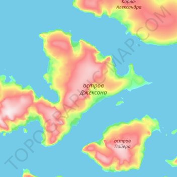
Name: Jackson Island topographic map, elevation, terrain.
Average elevation: 82 m
Minimum elevation: -1 m
Maximum elevation: 480 m
Thank you for supporting this site ❤️
Make a donation
Make a donation
Other topographic maps
Click on a map to view its topography, its elevation and its terrain.
Franz Josef Land
Russia > Arkhangelsk Oblast > Primorsky District
Approximately 85% of the archipelago is glaciated, with large unglaciated areas on the largest islands and many of the smallest ones. The islands have a combined coastline of 4,425 kilometers (2,750 mi). Compared to other Arctic archipelagos, Franz Josef Land is highly dissected, as a result of it being heavy…
Average elevation: 40 m
Thank you for supporting this site ❤️
Make a donation
Make a donation