
Tumbes topographic map
Interactive map
Click on the map to display elevation.
About this map
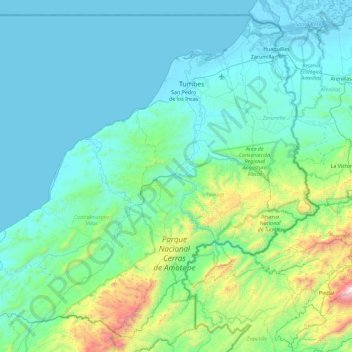
Name: Tumbes topographic map, elevation, terrain.
Location: Tumbes, Pérou (-4.23190 -81.04392 -3.39226 -80.12640)
Average elevation: 258 m
Minimum elevation: -4 m
Maximum elevation: 2,011 m
Other topographic maps
Click on a map to view its topography, its elevation and its terrain.
Canoas de Punta Sal
Canoas de Punta Sal, Province de Contralmirante Villar, Tumbes, Pérou
Average elevation: 155 m
Río Tumbes
Pérou > Tumbes > Pampas de Hospital
Río Tumbes, Pampas de Hospital, Province de Tumbes, Tumbes, Pérou
Average elevation: 422 m