
Thank you for supporting this site ❤️
Make a donation
Make a donation
Schöningen topographic map
Click on the map to display elevation.
Thank you for supporting this site ❤️
Make a donation
Make a donation
About this map
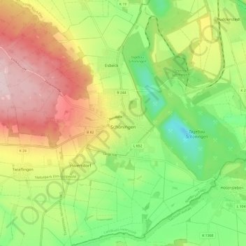
Name: Schöningen topographic map, elevation, terrain.
Location: Schöningen, Landkreis Helmstedt, Lower Saxony, 38364, Germany (52.09942 10.90808 52.17627 11.02792)
Average elevation: 137 m
Minimum elevation: 12 m
Maximum elevation: 297 m
Thank you for supporting this site ❤️
Make a donation
Make a donation
Other topographic maps
Click on a map to view its topography, its elevation and its terrain.