
Münichreith topographic map
Interactive map
Click on the map to display elevation.
About this map
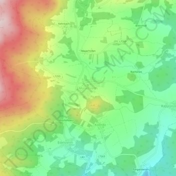
Name: Münichreith topographic map, elevation, terrain.
Location: Münichreith, Bezirk Melk, Niederösterreich, 3662, Österreich (48.24452 15.11098 48.28452 15.15098)
Average elevation: 684 m
Minimum elevation: 537 m
Maximum elevation: 910 m
Other topographic maps
Click on a map to view its topography, its elevation and its terrain.
Münichreith
Österreich > Niederösterreich > Münichreith
Münichreith, Bezirk Zwettl, Niederösterreich, 3623, Österreich
Average elevation: 713 m