
Stecknadelhorn topographic map
Interactive map
Click on the map to display elevation.
About this map
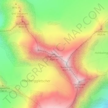
Name: Stecknadelhorn topographic map, elevation, terrain.
Location: Stecknadelhorn, St. Niklaus, Viège, Valais, 3924, Suisse (46.11145 7.85945 46.11155 7.85955)
Average elevation: 3,754 m
Minimum elevation: 3,162 m
Maximum elevation: 4,303 m
Other topographic maps
Click on a map to view its topography, its elevation and its terrain.
Dürrenhorn
Suisse > Valais > St. Niklaus
Dürrenhorn, St. Niklaus, Viège, Valais, 3924, Suisse
Average elevation: 3,525 m
Hohberghorn
Suisse > Valais > St. Niklaus
Hohberghorn, St. Niklaus, Viège, Valais, 3924, Suisse
Average elevation: 3,708 m