
Thank you for supporting this site ❤️
Make a donation
Make a donation
Adak Island topographic map
Click on the map to display elevation.
Thank you for supporting this site ❤️
Make a donation
Make a donation
About this map
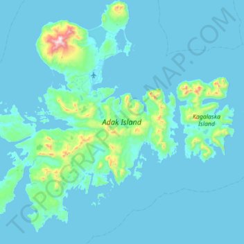
Name: Adak Island topographic map, elevation, terrain.
Average elevation: 68 m
Minimum elevation: -3 m
Maximum elevation: 1,144 m
Thank you for supporting this site ❤️
Make a donation
Make a donation
Other topographic maps
Click on a map to view its topography, its elevation and its terrain.
Chugach Mountains
United States of America > Alaska
The Chugach Mountains of southern Alaska are the northernmost of the several mountain ranges that make up the Pacific Coast Ranges of the western edge of North America. The range is about 250 miles (402 km) long and 60 miles (97 km) wide, and extends from the Knik and Turnagain Arms of the Cook Inlet on the…
Average elevation: 2,530 m