
Thank you for supporting this site ❤️
Make a donation
Make a donation
Aidone topographic map
Click on the map to display elevation.
Thank you for supporting this site ❤️
Make a donation
Make a donation
About this map
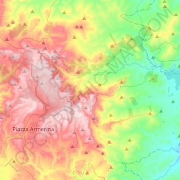
Name: Aidone topographic map, elevation, terrain.
Location: Aidone, Enna, Sicily, 94020, Italy (37.34829 14.38624 37.50906 14.63370)
Average elevation: 498 m
Minimum elevation: 174 m
Maximum elevation: 899 m
Thank you for supporting this site ❤️
Make a donation
Make a donation
Other topographic maps
Click on a map to view its topography, its elevation and its terrain.