
Make a donation
Bath topographic map
Click on the map to display elevation.
Make a donation
Bath
Bath is also 100 miles (160 km) southwest of New York City and 60 miles (96 km) northwest of Philadelphia. It is also located near Wind Gap as well as the Delaware and Lehigh water gaps. Bath's elevation is 432 feet (132 m) above sea level as of 2011. The Borough is hilly and has many steep roads. There are two peaks in Bath, Hawk Mountain in the northeast, and Siegfried Hill in the southwest, which has been partially quarried out. Monocacy Creek, a tributary of the Lehigh River, flows through the town's center. The East Branch Monocacy also flows through Bath until their convergence further south. Other bodies of water include Penn-Dixie pond (the remains of a former quarry), the quarries at Keystone Cement, and numerous small ponds on the outskirts of town. Many mills operated using the flow of the Monocacy. Race and Mill street are named after them.
Make a donation
About this map
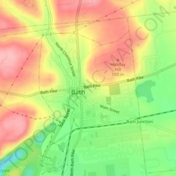
Name: Bath topographic map, elevation, terrain.
Location: Bath, Northampton County, Pennsylvania, United States (40.71836 -75.40142 40.73587 -75.38111)
Average elevation: 152 m
Minimum elevation: 81 m
Maximum elevation: 212 m
Make a donation
Other topographic maps
Click on a map to view its topography, its elevation and its terrain.
Illick's Mill Road Gateway
United States > Pennsylvania > Northampton County > Bethlehem
Average elevation: 105 m
Kreidersville
United States > Pennsylvania > Northampton County > Allen Township
Average elevation: 151 m
Make a donation
Danielsville
United States > Pennsylvania > Northampton County > Lehigh Township
Average elevation: 254 m
Portlamd Waterfront Park
United States > Pennsylvania > Northampton County > Portland
Average elevation: 118 m
Weaversville
United States > Pennsylvania > Northampton County > East Allen Township
Average elevation: 129 m
Make a donation
Moorestown
United States > Pennsylvania > Northampton County > Moore Township
Average elevation: 219 m
Martins Creek
United States > Pennsylvania > Northampton County > Lower Mount Bethel Township
Average elevation: 127 m
Mount Bethel
United States > Pennsylvania > Northampton County > Upper Mount Bethel Township
Average elevation: 156 m
West Bangor
United States > Pennsylvania > Northampton County > Washington Township
Average elevation: 310 m
Make a donation
Mount Bethel
United States > Pennsylvania > Northampton County > Upper Mount Bethel Township
Average elevation: 156 m
Morgan Hill
United States > Pennsylvania > Northampton County > Williams Township
Average elevation: 147 m
Leithsville
United States > Pennsylvania > Northampton County > Lower Saucon Township
Average elevation: 162 m
Make a donation
Northwood Heights
United States > Pennsylvania > Northampton County > Palmer Township > Palmer Heights
Average elevation: 110 m
Brodhead
United States > Pennsylvania > Northampton County > Bethlehem Township
Average elevation: 115 m
Make a donation