
Make a donation
Lānaʻi topographic map
Click on the map to display elevation.
Make a donation
Lānaʻi
The highest point in Lanai is Mount Lānaʻihale. It is an inactive volcano near the center of the island and to the east of Lanai City. The elevation of Mount Lānaʻihale is 3,366 ft (1,026 m).
Make a donation
About this map
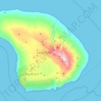
Name: Lānaʻi topographic map, elevation, terrain.
Location: Lānaʻi, Maui County, Hawaii, 96763, United States (20.73171 -157.06163 20.92934 -156.80555)
Average elevation: 162 m
Minimum elevation: 0 m
Maximum elevation: 1,020 m
Make a donation
Other topographic maps
Click on a map to view its topography, its elevation and its terrain.
Piʻiholo
United States > Hawaii > Maui County
Piʻiholo is a mountain summit on the island of Maui in Hawaii. It is at 20°51′7″N 156°17′33″W / 20.85194°N 156.29250°W / 20.85194; -156.29250 and has an elevation of 689 meters (2,260 feet).
Average elevation: 587 m