
Thank you for supporting this site ❤️
Make a donation
Make a donation
Naberezhnye Chelny topographic map
Click on the map to display elevation.
Thank you for supporting this site ❤️
Make a donation
Make a donation
About this map
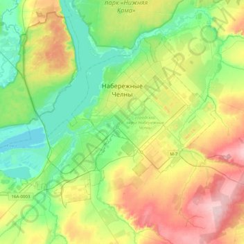
Name: Naberezhnye Chelny topographic map, elevation, terrain.
Location: Naberezhnye Chelny, Tatarstan, Volga Federal District, Russia (55.63560 52.18355 55.78999 52.57365)
Average elevation: 115 m
Minimum elevation: 49 m
Maximum elevation: 231 m
Thank you for supporting this site ❤️
Make a donation
Make a donation
Other topographic maps
Click on a map to view its topography, its elevation and its terrain.