
Thank you for supporting this site ❤️
Make a donation
Make a donation
Edwardsville topographic map
Click on the map to display elevation.
Thank you for supporting this site ❤️
Make a donation
Make a donation
About this map
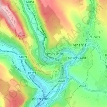
Name: Edwardsville topographic map, elevation, terrain.
Average elevation: 188 m
Minimum elevation: 79 m
Maximum elevation: 376 m
Thank you for supporting this site ❤️
Make a donation
Make a donation
Other topographic maps
Click on a map to view its topography, its elevation and its terrain.
Maerdy Park
United Kingdom > Wales > Merthyr Tydfil County Borough > Merthyr Tydfil
Average elevation: 223 m
Gelligaer Common
United Kingdom > Wales > Merthyr Tydfil County Borough > Trelewis
Average elevation: 309 m
Thank you for supporting this site ❤️
Make a donation
Make a donation
Taf Fechan
United Kingdom > Wales > Merthyr Tydfil County Borough > Trefechan
Average elevation: 297 m