
Mäusdorf topographic map
Interactive map
Click on the map to display elevation.
About this map
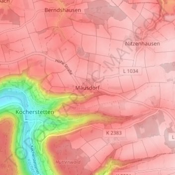
Name: Mäusdorf topographic map, elevation, terrain.
Average elevation: 400 m
Minimum elevation: 222 m
Maximum elevation: 455 m
Other topographic maps
Click on a map to view its topography, its elevation and its terrain.
Schloss Stetten
Deutschland > Baden-Württemberg > Hohenlohekreis > Künzelsau > Mäusdorf > Schloß Stetten
Schloss Stetten, Burgallee, Residenz Schloß Stetten, Schloß Stetten, Mäusdorf, Künzelsau, Verwaltungsgemeinschaft Künzelsau, Hohenlohekreis, Baden-Württemberg, 74653, Deutschland
Average elevation: 369 m