
Praia das Pedrinhas topographic map
Interactive map
Click on the map to display elevation.
About this map
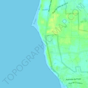
Name: Praia das Pedrinhas topographic map, elevation, terrain.
Average elevation: 4 m
Minimum elevation: -1 m
Maximum elevation: 15 m
Other topographic maps
Click on a map to view its topography, its elevation and its terrain.
Praia de Ofir
Praia de Ofir, Apúlia e Fão, Esposende, Braga, Portugal
Average elevation: 2 m
Praia Suave Mar (Norte)
Praia Suave Mar (Norte), Cepães, Esposende, Marinhas e Gandra, Esposende, Braga, Portugal
Average elevation: 5 m
Palmeira de Faro
Palmeira de Faro, Palmeira de Faro e Curvos, Esposende, Braga, Portugal
Average elevation: 72 m