
Thank you for supporting this site ❤️
Make a donation
Make a donation
Lörrach topographic map
Click on the map to display elevation.
Thank you for supporting this site ❤️
Make a donation
Make a donation
About this map
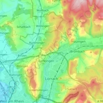
Name: Lörrach topographic map, elevation, terrain.
Average elevation: 356 m
Minimum elevation: 248 m
Maximum elevation: 571 m
Thank you for supporting this site ❤️
Make a donation
Make a donation
Other topographic maps
Click on a map to view its topography, its elevation and its terrain.
Obertüllingen
Germany > Baden-Württemberg > Landkreis Lörrach > Lörrach > Untertüllingen
Average elevation: 307 m
Nordschwaben
Germany > Baden-Württemberg > Landkreis Lörrach > Rheinfelden (Baden)
Average elevation: 446 m
Lippisbacher Hof
Germany > Baden-Württemberg > Landkreis Lörrach > Obereggenen
Average elevation: 645 m
Thank you for supporting this site ❤️
Make a donation
Make a donation
Elbenschwand
Germany > Baden-Württemberg > Landkreis Lörrach > Kleines Wiesental
Average elevation: 789 m
Thank you for supporting this site ❤️
Make a donation
Make a donation