
Thank you for supporting this site ❤️
Make a donation
Make a donation
Candeglia topographic map
Click on the map to display elevation.
Thank you for supporting this site ❤️
Make a donation
Make a donation
About this map
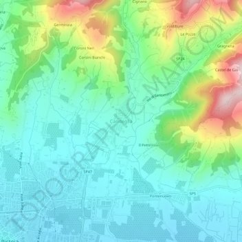
Name: Candeglia topographic map, elevation, terrain.
Location: Candeglia, Pistoia, Toscana, 51100, Italia (43.93357 10.92300 43.97357 10.96300)
Average elevation: 158 m
Minimum elevation: 57 m
Maximum elevation: 441 m
Thank you for supporting this site ❤️
Make a donation
Make a donation
Other topographic maps
Click on a map to view its topography, its elevation and its terrain.