
Make a donation
Saint-Jean-d'Aulps topographic map
Click on the map to display elevation.
Make a donation
Saint-Jean-d'Aulps
The inhabitants are called (in French) the "Jovanétiens". The commune is spread over 40.2 km2 (15.5 sq mi) and has 1,558 inhabitants (2019), 6,900 beds for tourists, 464 main residences, and 1,358 secondary residences. The population density is 39 inhabitants/km2 (2019). Saint-Jean-d'Aulps is surrounded by the communes of Seytroux, Le Biot, Abondance, Essert Romand and Bellevaux. The closest town is Thonon les Bains 25 km (16 mi) away. The river "la Dranse de Morzine" is the main water course through the village. In the commune, at an altitude of 805 m (2,641 ft), is the ski-area "l'Espace Roc d'Enfer". One can ski between 900 and 1,800 m (3,000 and 5,900 ft) above sea level and offers, amongst wild, unspoilt, and preserved terrain, 20 pistes (ski-runs) givings a total of 40 km (25 mi) of tracks. A large portion of these tracks are covered by artificial snow-making machines to make the skiing more snow-sure in lighter Winters. Saint-Jean-d'Aulps also offers many summer-time activities, namely: rock climbing, via ferrata, walking and hiking, mountain-biking routes, fishing, and para-gliding.
Make a donation
About this map
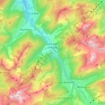
Name: Saint-Jean-d'Aulps topographic map, elevation, terrain.
Average elevation: 1,316 m
Minimum elevation: 673 m
Maximum elevation: 2,204 m
Make a donation
Other topographic maps
Click on a map to view its topography, its elevation and its terrain.