
Thank you for supporting this site ❤️
Make a donation
Make a donation
Washington County topographic map
Click on the map to display elevation.
Thank you for supporting this site ❤️
Make a donation
Make a donation
About this map
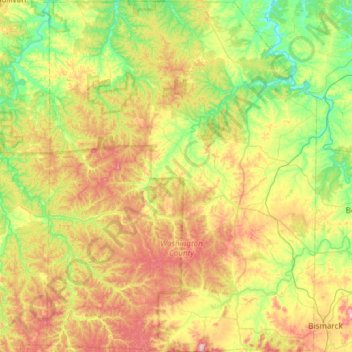
Name: Washington County topographic map, elevation, terrain.
Location: Washington County, Missouri, United States (37.73412 -91.10052 38.20674 -90.63993)
Average elevation: 279 m
Minimum elevation: 161 m
Maximum elevation: 479 m
Thank you for supporting this site ❤️
Make a donation
Make a donation
Other topographic maps
Click on a map to view its topography, its elevation and its terrain.