
Rickenbach topographic map
Interactive map
Click on the map to display elevation.
About this map
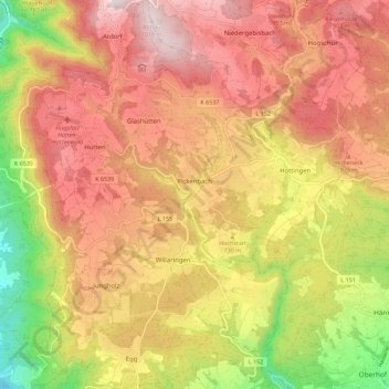
Name: Rickenbach topographic map, elevation, terrain.
Average elevation: 732 m
Minimum elevation: 331 m
Maximum elevation: 1,026 m
Située à 696 mètres d'altitude, la ville de Rickenbach a pour coordonnées géographiques Latitude: 47° 37' 13'' nord et Longitude: 7° 58' 42'' est.
Other topographic maps
Click on a map to view its topography, its elevation and its terrain.
Murg
Allemagne > Bade-Wurtemberg > Landkreis Waldshut > Murg
Murg, Verwaltungsgemeinschaft Bad Säckingen, Landkreis Waldshut, Bade-Wurtemberg, 79730, Allemagne
Average elevation: 520 m