
Mill Run topographic map
Interactive map
Click on the map to display elevation.
About this map
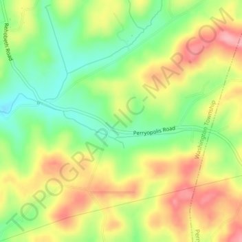
Name: Mill Run topographic map, elevation, terrain.
Average elevation: 333 m
Minimum elevation: 274 m
Maximum elevation: 395 m
Other topographic maps
Click on a map to view its topography, its elevation and its terrain.
Davis Island
United States of America > Pennsylvania
Davis Island, Stowe Township, Allegheny County, Pennsylvania, United States of America
Average elevation: 258 m
Lancaster County
United States of America > Pennsylvania
Lancaster County, Pennsylvania, United States of America
Average elevation: 158 m
Warren County
United States of America > Pennsylvania
Warren County, Pennsylvania, United States of America
Average elevation: 500 m
Erie County
United States of America > Pennsylvania
Erie County, Pennsylvania, United States of America
Average elevation: 272 m
Hill Island
United States of America > Pennsylvania
Hill Island, Dauphin County, Pennsylvania, United States of America
Average elevation: 95 m
Exeter
United States of America > Pennsylvania > Exeter
Exeter, Luzerne County, Pennsylvania, 18643, United States of America
Average elevation: 237 m
Sullivan County
United States of America > Pennsylvania
Sullivan County, Pennsylvania, United States of America
Average elevation: 491 m
Crawford County
United States of America > Pennsylvania
Crawford County, Pennsylvania, United States of America
Average elevation: 382 m
Davis
United States of America > Pennsylvania > Washington Township > Davis
Davis, Washington Township, Indiana County, Pennsylvania, 15747, United States of America
Average elevation: 381 m
Forest County
United States of America > Pennsylvania
Forest County, Pennsylvania, United States of America
Average elevation: 486 m
Dalmatia
United States of America > Pennsylvania > Dalmatia
Dalmatia, Northumberland County, Pennsylvania, 17017, United States of America
Average elevation: 172 m
Stewart Township
United States of America > Pennsylvania > Stewart Township
Stewart Township, Fayette County, Pennsylvania, 15470, United States of America
Average elevation: 603 m
Dauphin County
United States of America > Pennsylvania
Dauphin County, Pennsylvania, United States of America
Average elevation: 196 m
Lehigh County
United States of America > Pennsylvania
Lehigh County, Pennsylvania, United States of America
Average elevation: 186 m
Bedford County
United States of America > Pennsylvania
Bedford County, Pennsylvania, United States of America
Average elevation: 491 m
Philadelphia County
United States of America > Pennsylvania
Philadelphia County, Pennsylvania, United States of America
Average elevation: 39 m