
Thank you for supporting this site ❤️
Make a donation
Make a donation
Saint John topographic map
Click on the map to display elevation.
Thank you for supporting this site ❤️
Make a donation
Make a donation
About this map
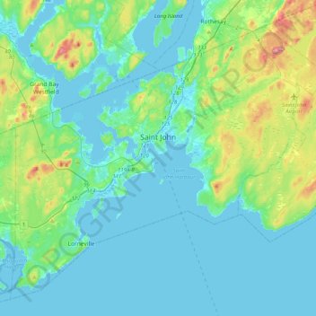
Name: Saint John topographic map, elevation, terrain.
Location: Saint John, Saint John County, New Brunswick, Canada (45.14150 -66.23940 45.37693 -65.83886)
Average elevation: 39 m
Minimum elevation: -8 m
Maximum elevation: 223 m
Thank you for supporting this site ❤️
Make a donation
Make a donation
Other topographic maps
Click on a map to view its topography, its elevation and its terrain.
Saint John
Canada > New Brunswick > Saint John
The topography surrounding Saint John is hilly; a result of the influence of two coastal mountain ranges which run along the Bay of Fundy – the St. Croix Highlands and the Caledonia Highlands. The soil throughout the region is extremely rocky with frequent granite outcrops. The coastal plain hosts numerous…
Average elevation: 44 m