
Phetchabun topographic map
Interactive map
Click on the map to display elevation.
About this map
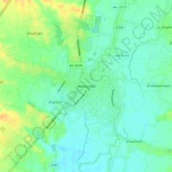
Name: Phetchabun topographic map, elevation, terrain.
Location: Phetchabun, Phetchabun Province, 67000, Thailand (16.37803 101.11568 16.45803 101.19568)
Average elevation: 120 m
Minimum elevation: 110 m
Maximum elevation: 140 m
Other topographic maps
Click on a map to view its topography, its elevation and its terrain.
Nong Phai
Thailand > Phetchabun Province
Nong Phai, Bua Watthana, Phetchabun Province, Thailand
Average elevation: 104 m
Phetchabun Province
Thailand > Phetchabun Province
Phetchabun Province, Thailand
Average elevation: 264 m