
Thank you for supporting this site ❤️
Make a donation
Make a donation
Nine Mile Burn topographic map
Click on the map to display elevation.
Thank you for supporting this site ❤️
Make a donation
Make a donation
About this map
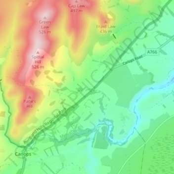
Name: Nine Mile Burn topographic map, elevation, terrain.
Location: Nine Mile Burn, Midlothian, Scotland, EH26 9LZ, United Kingdom (55.78557 -3.33358 55.82557 -3.29358)
Average elevation: 323 m
Minimum elevation: 204 m
Maximum elevation: 527 m
Thank you for supporting this site ❤️
Make a donation
Make a donation
Other topographic maps
Click on a map to view its topography, its elevation and its terrain.
Straiton Pond Local Nature Reserve
United Kingdom > Scotland > Midlothian > Loanhead
Average elevation: 131 m